Tin Hat through to Lewis Lake:
The longest 9 kilometers in the world.
 |
This section of trail is deceptive. By the map it's barely 10 kilometers, but it feels oh-so-much longer. It does have three remarkably steep sections near the top and, with all the switchbacks and elevation changes, the hiker might seriously want to consider overnighting at Lewis Lake or thereabouts. Your dogs will be barking.
|
I have issues with this trail: it's breathtaking in just so many ways, but I sure wish I was not completely spent when I get to the end of the hike.
I usually do this as a "there and back" hike, starting above Lewis Lake on the access road there, climbing to the hut and then reversing my steps. I admit that it's a bit of a cop-out to stop at the hut, but by the time I get over that last hill and see the sky-scraper out-house, I'm pretty much done with hills. I have been to the summit several times; I can skip the summit when I am trying to cough up a lung. Besides that, every time I climb Tin Hat, the clouds sense my approach and roll-in.
This last week's hike was to fill out my photo-array of this icon of the SCT. I'm still unhappy with the results since my normally trusty Olympus gave me nothing but muddy garbage. Thank goodness that I carried the finicky Canon as well on Saturday.
 |
| North from just below the summit 2020 |
 |
| West to Haslam Lake, 2020 |
 |
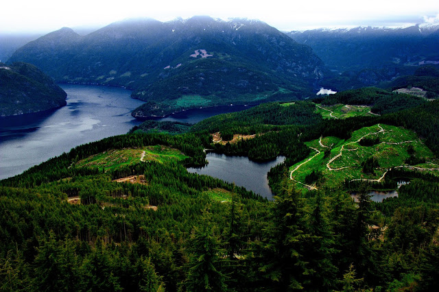
| Southwest, overlooking the Powell River Canoe Route. The distant mountain to the left is Troubridge, the last summit of the hike, while the range to the right is the Smith Range with Walt Hill dominating. |
 |
| The Smith Range is the subject: your future hiking experience. On the right edge of the range is about where Elk Lake Hut will be found (I think that first notch?) while at the left edge of the photo is Walt Hill with it's "all weather" hut. The central thread of the SCT winds across the western shoulder of the Smith Range for the most part. |
This Saturday's hike was not without it's amusing moments and personal revelations. I finally understand that I am indeed old now: not sort of old or maybe old, but definitely past my "best before date".
There are indeed three steep sections on the trail where a person wants to be careful with every step. Ascending , at a short and sharp rock climb, I ran into a party of 5 older but hardy ladies loaded with full packs. They paused their downward climb to allow me to pass....totally nasty and inhumane really. Upward hikers should be allowed to rest so they don't embarrass themselves wheezing by their descending counterparts. I pretended to be 20 again and hobbled by the ladies at my best hiking pace until....
One of the party graciously told me to beware of the crowd of "young people up at the summit". My balloon deflated as I realized that I was officially part of their social circle: I was Senor Senior. No longer a spry youngster. I would guess my grunting, wheezing and faltering pace as I passed the climbers gave me away.
I felt no need to pretend after that.
 |
| The summit from the shoulder. Going up the North Face would be "cliffy". Really "cliffy". |
 |
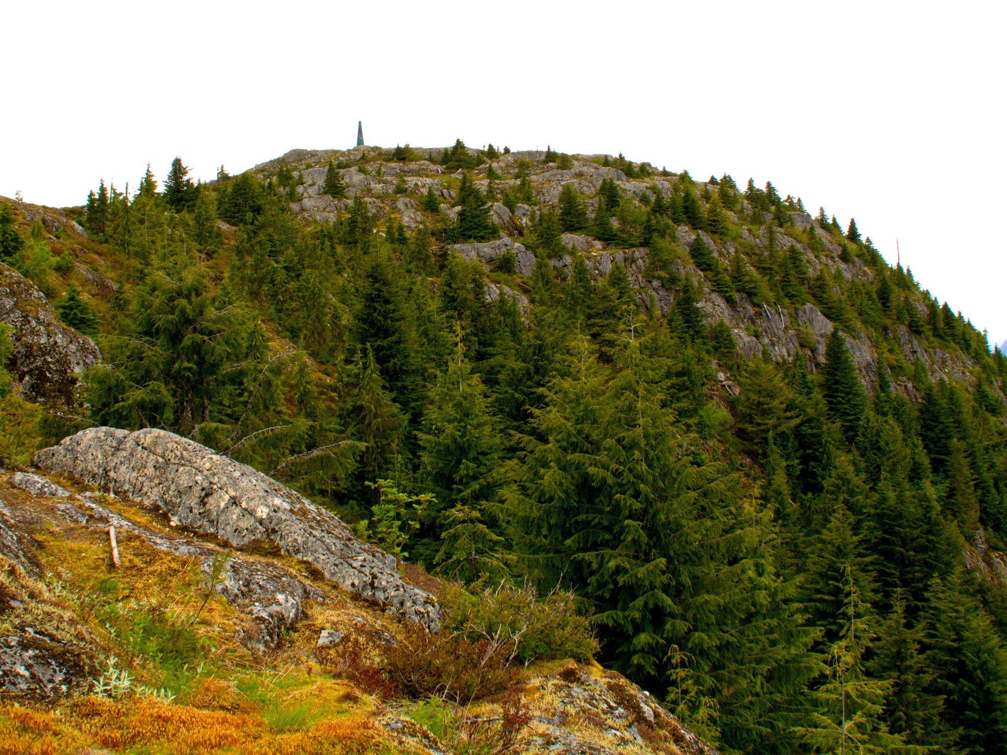
| The obligatory summit shot of the hut. Done much better elsewhere. After the trail up, climbing to the summit is a joy: hiking in the alpine without the salal, ferns and blackberry to hold you back. |
Another amusing story of elder comeuppance (getting old sucks for an ex-jock).
While I rested my sorry ass on the steps of the hut, pretending not to see the younger people inside the COVID forbidden hut, I noted a couple of spry hikers bouncing down from the summit at a stiff pace. You would have thought I was seeing mountain goats in bright jackets.
I did not think much beyond "wow, they ARE agile" as I decided to quickly leave the summit crowd behind and get back home. I headed back down the East approach, somewhat dreading the tortuous descent on my already spent legs, wondering how fast I can still "tuck and roll" if I slipped.
 |
| Spring 2020: the East arm of Powell Lake, the short Goat River and Goat Lake in the distance. |
 |
| Summer 2021. From about the same place. |
 |
| A boat cuts a wake along the East Arm of Powell Lake. |
As I descended the first small hill, just a prelude to the cliffs ahead, I heard the chatter of Korean behind me. The voices were youthful, so I thought I would discretely pretend to be taking some photographs as my companions passed me by. I still have some pride and I sure as heck did not want to have anyone see me keel over dead trying to keep ahead of the pack. Two young ladies raced by, their bright jackets making them easy to track through the trees. They were the two nimble mountain goats I had spotted before.
Not to much farther along, having edged down the first steep section (not just steep: unstable rock on top of hard granite: you need to make sure to brush those pebbles away at each step to make sure you have good purchase), I came upon a long, narrow traverse across a granite shelf. I spotted the two young ladies far below me, substantially off the trail and getting themselves in trouble. I stopped and called out that they needed to go back up the way they came (arrogantly assuming that their command of English would be poor; I spoke slowly and loudly. What an ass).
I was wrong. The taller of the two girls just scrambled up the steep bluff like a squirrel, barely needing to catch her breath as she told me to lead on. The joy of youth; her English was just fine. No fool like an old fool.
The next sharp cliff, just on the other side of the granite shelf, would make anyone (except my young companions) pause and think. It really is quite steep, has some stony scrabble over top and the landing would be very solid if one fell.
I inched down the cliff, happy to finally get to flat ground at the bottom. My Korean colleagues raced down the cliff as if it was a city side-walk.
Deciding that I had fulfilled my youthful adventure quotient of the day, I stepped aside and pretended to take more pictures of the rock face. An exchange of greetings ended my leadership. They had come from Nanton Lake: by my count they would complete over 30 kilometers of hiking that day by the time they got back to camp.
Despite the fact voices carry a long way in the mountain air, I soon lost contact with the two intrepid hikers. There really was no hope of me ever keeping pace with them, even four decades ago.
 |
| Somehow that hill looks steeper when you are standing on top of it. Much steeper. I did catch the nature of the footing: those pebbles are not quite ball bearings, but when your legs are a bit shaky, they might as well be. |
 |
| From the stone shelf above the sharp downhill climb. Goat Island with it's resident lake, surrounded by Powell Lake. Fiddlehead Landing would be just around that bend, across from the logging cut visible at the lower left of Goat Island. |
The East Tin Hat trail basically tracks along the edge of a long hog-back leading down and inevitably east. You will catch glimpses of Powell Lake to the North and you are never too far from a view of your destination, Lewis Lake, below. The trail is mostly down, but there are quite a number of uphill grades to break the will of the tired hiker. I always seem to forget those grades on my return trip and the internal whining is deafening as I inch my way up yet another hill.
You really CANNOT count on potable water anywhere on the upper reaches of the trail. There certainly are a few seasonal creeks; one creek in particular was my salvation in 2020: finding it high on the mountain I rejoiced in sipping it's ice cold waters through my emergency filter. Through my filter: I repeated that to remind people that "Beaver Fever" or Giardiasis is an unpleasant souvenir of the SCT if you are incautious about your water sources.
The trail itself weaves north and south in succession, always trending East. Just above the last steep section is a fantastic granite shelf where a person should stop and enjoy the view. The granite shelf is a surprise as one climbs up from Lewis Lake: a hiker sees it from below but never really dreams they will climb up the gully along the south edge and then cross over the wide lip atop.
The first of the "bridges" crosses one of these little streams. The log that serves has seen better days and I would think that if it is a little wet, it might be a bit slippery. I know that I didn't dawdle while crossing this little gully; it would have been less than a three foot fall, but the inevitable torn pants, cut shins and mud stained jacket would have had a embarrassing tale to tell when I got home.
The three bridges along the East Tin Hat trail are not the elaborate construction seen elsewhere on the SCT, but then this is a relatively new section of the trail. In early spring of 2020 the trail was difficult to find in some places while in mid June of 2021 the trail was well trod and hard to miss. Of course, mid June is the real beginning of the high season for hiking, even during the COVID plague.
The larger two bridges sit below the single logging road the hiker will cross while coming down the trail. That logging road, to me, marks the true end of Tin Hat Mountain. At this point the hiker will pass across a swampy area (bridge one) and into an old forest that fills a deep gully leading downhill towards the trail-head of the Lewis Lake access.
 |
It looks like a log, it rots like a log and it's split like a log...but it's really a bridge. Truthfully crossing it was not really all that bad; short, sweet and quite stable.
|
 |
| Good and bad: good that it's only a foot or so above a shallow bog, bad that it's long and feels a bit tippy. Or maybe I just felt a little tippy...hard to say |
 |
| The last of the bridges: it crosses a rapidly flowing stream and it would be quite unpleasant to trip on. |
The last of the trail down to the trail head is a joy. It has a little of the feel of the pass leading from the West into Confederation Lake. Many giant trees still line the walls of the valley and the canopy above is thick and shady.
There is a small lake hidden at the top of the valley. It's hard to spot through the foliage and even harder to approach for viewing. My GPS unit gave my wife a bit of scare as she tracked my hike on the computer at home: according to the GPS tracker I had inexplicably wandered off the trail into the center of the lake. The next GPS ping showing me back on dry land and heading south probably just destroyed her victory dance over winning the life-insurance lottery.
Below the lake there is a small trickling brook heading inevitably toward Lewis Lake. This brook is soon joined by a fast flowing stream rushing down a stone watercourse and just begging for the thirsty hiker to stop and enjoy the mountain waters. This loud brook is the first really trustworthy water source coming down the trail; it was my absolute salvation on my first hike up this trail. Unfortunately, the joy of drinking crisp, cold mountain water falls a little flat when it is sucked with great effort through a biofilter.
The thirsty hiker can anticipate this cold delight, but it's a little late coming since, by this time, the hiker is really only about 30 minutes North of Lewis Lake. |
| The hidden lake, hiding behind a thick ring of trees. |
 |
| Spring of 2020: those white dots that mar the photograph were bugs. Millions and millions of bugs. Lucky my blood must taste bad since I rarely get bitten. |
 |
| There really is no way of conveying how big these fallen giants really were. That cedar in the middle of the photograph probably crushed ten other trees when it fell. |
 |
| Looking up the valley to a sunny clearing from beside the trickling brook. To a guy who spent the majority of his adult life in the prairies, these forests still hold a mystical sway over me. |
 |
| Even in 2021, when I had carried enough water for the long hike, this creek called to me. My mouth felt like desert-dried leather and I could almost taste the ice cold water. I held off; the truck was less than ten minutes away. |
 |
| The trail head above Lewis Lake. You need to drive by the access to the Lewis Lake camp ground and continue along until you are directly north of Lewis Lake. Cross a steel bridge and watch for an obvious parking space just past the cairn set up to mark the trail head to the path along the shores of Lewis Lake. |
After the challenging and perhaps grueling ordeal of Tin Hat, the hiker has earned a little relaxation before tackling the upcoming traverse of the Smith Range. The Lewis Lake segment is that relaxation. The trail is best described as an idyllic, soft, shady and green passage along the shores of usually placid Lewis Lake. There is a definite Tolkien vibe of Middle Earth; you might even break into the chorus of "The Road Goes Ever On". If it did not mean an hour drive over dusty logging roads, this trail would be an absolute favorite for my wife, a "fair weather hiker" with bad knees.
 |
| The top of the trail leading down to Lewis Lake. The cairn is relatively new and seems to be growing every time I visit this spot. The widening of the road for parking is just adjacent to this rock pile. |
 |
| The first section of the trail creeps along the edge of a older clear cut with well established cultivated trees creating a corridor of green. |
 |
| I don't always hike solo, and when I do hike with others, they are always the best type to hike with.. |
 |
| The trail is amazingly soft, thick with moss, pine needles and years of rotted wood. |
 |
| It's a thick forest, filled with mature second growth trees. I would hope this area is protected by it's close proximity to Lewis Lake. |
 |
| The iconic Tin Hat in reflection: look how far you have come in just a few hours. |
 |
| I was just having too much fun working with the near perfect reflections and I cannot pass up the chance to show off. That's the "hog-back" the hiker just navigated. |
 |
| Seen along the trail. Somebody has a sense of humor and too much time on their hands. |
 |
| An important crossing of a sorts. Just on the other side of the bridge the trail will fork: the left branch leads onward down the SCT toward the Smith Range, the right branch to the provincial campground. |
It should be noted that there is a small camping area along the shores of Lewis Lake, large enough for maybe a couple of tents. There is an outhouse a ways uphill and a picnic table where one can share their repast with wayward bears or random hobbits. Another kilometer of easy walking will take you to the provincial campground along the south shore of Lewis Lake.
 |
| One always needs to remember that, no matter how bad things look tonight, the sun will still rise in the East tomorrow. Taken from the Bend on Goat Main at some unGodly hour of the morning when even the squirrels are grabbing some shut-eye. |
Ni edrych angau pwy decaf ei dalcen :Death considers not the fairest head. This I know better than most; none of us are spared, so live well for yourself and the one's the wolves pull down.


Ian, your posts are fantastic. I'll be hiking the first section from Sarah Point (for the first time this summer) and your photos and commentary make me want to just keep going so I can see all these amazing places. Thank you for posting these!
ReplyDelete