LEWIS LAKE THROUGH TO ELK LAKE:
yes, it is a long haul, but there really is only one hill-climb.
 |
| this section of the trail is really understated. I actually find it to be very pleasant; it's easy enough to allow one to actually enjoy the views of the valley below. |
Well, I'm going to admit that this entry is going to be a bit of smoke and mirrors. I have not actually hiked the entire length of this section in one jump: it's along haul and I really don't like overnighting it. I'm just too addicted to my morning shower, clean sheets, and cold beer. Doing the section between Lewis Lake and Elk Lake as a "there and back" requires feet of steel and an iron constitution that I lack. I probably could do this as a "two car" hike, but the access roads I frequent are not always user-friendly and I'm not sure I want to subject any truck other than my own to the "Powell River Pinstriping" that is inevitable from the overgrown access roads.
What I ended up doing is hiking as far as I could from the Lewis Lake side and then turning around at a set "turn back time" (like climbing Everest without the crowds, the suffering and corpses lining the trail like macabre cairns). A few weeks later I hiked in from the Old Alaska Pine Road access to Elk Lake.
This strategy would have been perfectly successful if I had not depended on my unrevised GPS track of the SCT and managed to go miles out of my way while enjoying the desolation of logging. Common sense should have made me question the wisdom of bulling my way through a freshly cut logging road.
People that live in wood frame houses best not complain too loudly about the industry that provides that wood.
 |
| The trail head as it crosses the access road to Lewis Lake campground. This is a continuation of the placid trail that skirts Lewis Lake covered in the last section. |
 |
The trail up to March Lake, for the greater part, follows a series of gentle logging trails. The climb up the east flank of the Smith Range is gradual but continuous. The hiker will gain a fair bit of altitude but really not notice the effort due to the long and low grade ramp.
|
 |
"The road goes ever on and on, Down from the door where it began,
Now far ahead the Road has gone and I must follow if I can....." Tolkien |
 |
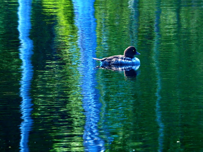
| Spring Lake and the most camera-shy ducks in the world. |
 |
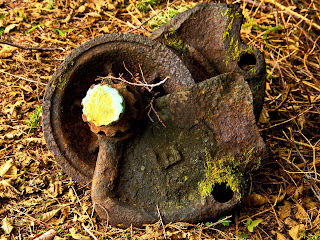
| A giant's flower pot sits atop a lake-bound island. No idea what it really is. |
 |
| The crossing at Spring Main right at Spring Lake. |
 |
"Pursuing it with eager feet, Until it joins some larger way
Where many paths and errands meet. And wither then?
I cannot say..." Tolkien |
 |
| A left over from the days when logging was pretty much a free-for-all . |
 |
| Down in the valley of the Canoe Route. |
 |
| If you pass this stump, you have gone too far. Back up a few paces and make a hard right uphill. |
 |
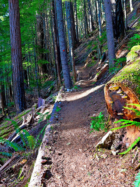
| Looking southwest along the trail. The trail skirts a relatively recent logging cut, so the views are pretty spectacular. Just remember that the view came at the cost of a biome. |
 |
| The odd bridge crosses some muddy points and there is the ever present flotsam and jetsam of logging strewn along the trail. |
 |
| A dangerous attack squirrel. Potentially more dangerous than a Grizzly..... if you are a peanut. |
Coming from Lewis Lake I finally ran out of steam 3 or 4 kilometers short of March Lake. I sat down on a rotting log and stared out over the valley below as I sipped cold water and munched on granola bars. My dogs were barking pretty loud and I had a somewhere between two or three hours return trip to the truck.
The photographer in me committed to coming back on an uncloudy day to really appreciate the lakes below. The view here would be magical during the golden hours just before sundown. Unfortunately, many SCT hikers look upon this section as merely a transit between the lofty heights of Tin Hat and the isolated Elk Lake Valley.
Note to self: find the road access to this logging cut so I can be there in the golden hour.
Several weeks after I hiked in from Lewis Lake, I came at the trail from the other direction: using the access trail off of the Old Alaska Pine Road (narrow and gnarly most of the time) I hiked up to Elk Lake Hut first and then headed down toward March Lake, hoping to find the lunch site of my last visit.
There is no fool quite like an old fool.
I had reviewed the published maps of the SCT and completely forgotten to take into account the re-routes forced upon the builders by the logging along the way. I had the old route locked in my head and, darn it, that was the way I was going to hike.
When I got to the bottom of the Elk Lake hill I did not even pause to consider my situation...I just walked toward the light.
The light that was created by the massive logged out area occupying the previous SCT route. Through the curtain of the remaining forest the light effect was magical.
Unfortunately, one foot past that curtain and I felt like the Ent "Treebeard" as he looked out upon the remains of his decimated forest. I knew that somewhere under that muck and mire lay the old SCT, and, being an especially stubborn man, I insisted on walking down that not-quite-finished logging road in search of the remains of the trail.
It never occurred to me to look for a re-route...and I walked right by the very well marked new SCT which followed the edge of the north side of March Lake.
I knew I really am a stubborn fool when I found that re-route on my return journey three hours later.
 |
| From the "Lunch Stump", my approximate turn around point of the last visit here. |
 |
| Looking North by Northeast from my make-do picnic table. The yon mountains call for another visit: Emma Lake and the legendary South Powell Divide are up there somewhere past Goat Lake. |
 |
| The trail follows old logging trails for the most part. Typical of these mountains, watercourse and logging road become on and the same without maintenance. |
The old SCT route followed some old logging roads long since grown over with mature forest. The trail was reasonably flat and almost pastoral as it tracked along the edge of March Lake.
About half-way down the length of March Lake, there is an access to a small camping area along the edge of the lake. That camping spot is still there and the access trail can still be found, but the determined hiker will have to brave an active logging road and plunge over a steep, rocky embankment to get there. It's not really worth the danger and the effort.
Having reached the end of the logging road, I had to consult the GPS track for several moments as I walked up and down the stony road (note: it had still not occurred to me that I was missing an important detour; talk about single minded) before I found the remains of the old SCT. I hopped down a steep embankment and found the remains of the SCT again following an old logging road.
That trail eventually led to a rushing stream that I had to ford to access the obvious continuing trail on the other side. I now know that there was a bridge a scant few meters upstream of my position, but what the heck, I'm not so old that a little aquatic hop-scotch across some mid-stream stones is beyond my ability. I did not consider the challenges of the return journey (and it still had not dawned on me to look for a safe detour).
Suffice to say, I was relieved when I got to the other side of the creek and found the proper SCT trail again. It felt like I was home free after nearly and hour of stumbling around stupidly.
Getting across that stream on my return journey was another matter altogether.
Funny thing there: that stream did not look nearly as deep and wide as I hiked in fresh and spry. Coming back it actually took a leap of faith to cross it: bouncing off an old log, taking a running step on a midstream rock (hoping it was stable) and then leaping to the far bank. I was quite proud of myself when I landed that athletic feat.
I can actually hear all the twenty-something hikers giggling at my small victory.
Beware: time catches up to all of us.
Time is a funny thing: in your youth it creeps by, each day filled with new opportunity and hope. On the down side of fifty, each day dawns with a new ache and pain and there NEVER seems to be enough time. Youth is indeed wasted on the young; if I had fifty more years I still would not get half of my bucket list completed.
 |
| The old trail and the new road. Just a bit different. |
 |
| Off the old trail branches the access to the March Lak camping spot. It's still there, or at least a sad little orange marker on a tree stands in as a tombstone. |
Today I returned to investigate the new SCT route around the North side of March Lake. I drove back up Old Alaska Pine Road and hiked into March Lake. To my chagrin, somebody must have told the loggers that there is at least one stupid old man out there stumbling along their logging road, because my original path through the new cut is now blocked off with rope and several signs warning of danger, dismemberment and death. I think somebody probably wanted to scrawl "This means you!!!" at the bottom of the signs.
Either way, I had only two choices at that point: go north onto the new bypass or go south up to Elk Lake. I went north.
Now, tracking my path south from my lunch spot of the first visit to this hillside coming down from Lewis Lake.
The SCT wanders across the top of some relatively recent clear cuts, sometimes following fading old logging roads, sometimes snaking along well established trails. There are a few swampy areas along the way and in a couple of places the "forest" the hiker is passing through is just a vestigial corridor of trees flanked by clear-cuts on either side.
Eventually the hiker will descend gently down the hillside and step out of the forest, crossing a ditch by a small bridge, and end up at a cross-roads of a sort. Downhill, about fifty meters north and east of the bridge will be the next segment of the SCT. This section is quite magical.
From here the trail drops over the edge of the road and just a few meters down the trail it will drop over the edge of a steep cliff, descending through a series of switch-backs into an area of old truly beautiful old growth.
That series of switch-backs is a testament to the engineering prowess and diligence of the trail builders. The construction of that short segment must represent weeks of damned hard work by a dedicated team...and they even took the time to build some benches to rest on at several of the tight corners. Talk about going above and beyond.
The SCT from here tracks along at the base of the cliff, old grandfather trees, several centuries older than the town of Powell River, tower above your head. I still get a little boggled when I think of a living organism that has stood since Vancouver was an explorer rather than "the big city" two ferries and a gnarly road away.
Eventually the trail climbs up a steep gully and out into a clear cut. The ubiquitous orange tags are a scant here, but a hiker would have to be blind to miss the well trodden trail that cuts across the southeast corner of the clear cut. The new SCT bypass starts here; only me and a blind man could miss the extremely well marked beginning of this path. Again, I have a suspicion that a posting of my first misadventure along this section might have poked the SCT volunteers to convince misguided fools to actually look up from their GPS and follow the trail.
The new, most likely permanent track of the SCT is a real improvement on the old trail. It meanders through a relatively young forest (therefor safe from logging for several decades) wedged between March Lake and a clear cut. The trail is soft, and rambles around the lake edge, gently rising and falling over hillocks and through hollows.
There is a single access to the to lake edge; today I failed to get any photos during the "golden hour" since some hikers were sleeping soundly as I silently passed. I was a bit sad; I had got up at the unGodly hour of 4:15 am so I could catch that light. but even I know it's impolite to wander into a private camp at 7 am. Besides, they might think I was a bear and shoot a damned "bear banger" at me.
And that brings us back to the bottom of the climb to Elk Lake.
I did say that there was one hill climb on this section. It starts here.
The climb up to Elk Lake is a good climb. It has it's steep parts, but for the most part it's just consistently up, climbing through a young forest through a series of switch-backs and steep traverses. Eventually the hiker will hear the rushing water of the creek draining Elk Lake, bouncing down the hillside in a series of small waterfalls. Just a few more bends in the trail and the hiker will see the light at the end of the trail: you've arrived at Elk Lake.
The hut at Elk Lake is a pleasant open concept shelter, perched above the lake, a rudimentary dock extending out into the lake. There is a canoe for the paddlers among us and a deck for sunning after a brisk swim in the cold mountain lake.
 |
| Down the hill, out of the forest and across the bridge. Look to your left, down the hill for the trail to the old forest. |
 |
| The wonder of this: a young healthy tree growing over the root of a grandfather. Here begins the descent into the old forest. |
 |
| Winding down the cliff face, to and fro, one hiker wide but well built and wonderful. |
 |
| The new trail wanders up the course of March Creek. The trees are young and it will be decades before they are mature enough to harvest. |
 |
| The remains of the old trail beckon: ignore the call, it goes nowhere good. |
 |
| A little hiker hopscotch just to check your coordination. after a tiring hike. |
 |
Obviously the SCT volunteers REALLY don't want to lose any hikers.
|
 |
| A true trail along the edge of a clear cut. |
 |
| From the edge of a backwater bay of March Lake, where the lone camping spot, space for one, lies just off the trail |
 |
| Continuing beyond the edge of the lake the trail is well developed despite it's recent construction. It will climb gently up to the old logging road that marks the beginning of the climb to Elk Lake. |
 |
| Do NOT go toward the light. It's just not good. |
 |
| The entrance to the climb. It starts as a gentle rise and then just gets steeper. No fear: it's short and sweet. |
 |
| You cannot give the essence of steep. |
 |
| Listen for the rushing Elk Creek waterfalls to the right of the trail. |
 |
Finally, as the sweat dries across the back, Elk Lake. That's the dock there. Today it was a sunning deck as a young woman strolled out in a barely-there bikini. I left: old men with telephoto lenses are best to just depart in these situations.
|
 |
| Finally: The Hut |
 |
| I'm just proud of this shot. Swimming on Elk Lake |
 |
| Dragon Flies are just cool. |
 |
| There is beauty everywhere:. living in the prairies teaches one to see out to the horizon and dream of what is on the other side. The road goes ever on. |
A fynno glod, bid farw: The best way to garner praise is to die. Indeed, little white lies are told at every funeral.


Comments
Post a Comment