Walt Hut to Golden Stanley Hut:
 |
This section appears to be the beginning of the "extra tail end" of the SCT: so many people seem to call it a hike when they make it to Dixon Road (Goat Main) and wander out to the Lang Bay Store. You are missing some of the best of the trail and the hike is not over until the hike is over.
|
The section from Walt Hut to the Golden Stanley Hut (don't you love the name?) is pretty much pastoral. The descent off Walt Hill itself is a bit precipitous (but far more civilized than it once was), but once the hiker makes it out onto the barely-there tail end of Branch 21, there are really no major physical challenges ahead until the hiker starts the short and sharp climb up to the actual Golden Stanley Hut.
From the beginning of the Suicide Pass Trail, through the Smokey Blue Ridge and down to Dixon Road the trail is pretty much all downhill. Some of it is a little steep...but the builders threw in a very civilized cement staircase at one point. The majority of the trail is easy hiking and in some places dramatic: some crazy booger set up a couple of tables and settings for high tea at one point (high tea is no longer; the tables are now gone).
 |
| From the last viewpoint on the descent, a sharp bluff across which the SCT courses. That's Troubridge, the tallest and last of the SCT climbs. |
 |
| Looking down the lake, Lois Lake Fish Farm. Here is the magic of a 300 mm zoom lens. |
 |
| A lakeside get-away beckons from nearly a mile away. |
 |
| The relatively steep descent off the top, followed by a sudden emergence onto a stark bluff with an outstanding view. |
 |
| The old growth forest at the top of Walt Hill. |
 |
| For some reason, the first time I saw these old trees I thought of two fallen soldiers propped against stone embattlements. I have no idea where that came from. I was playing with leading lines here. |
 |
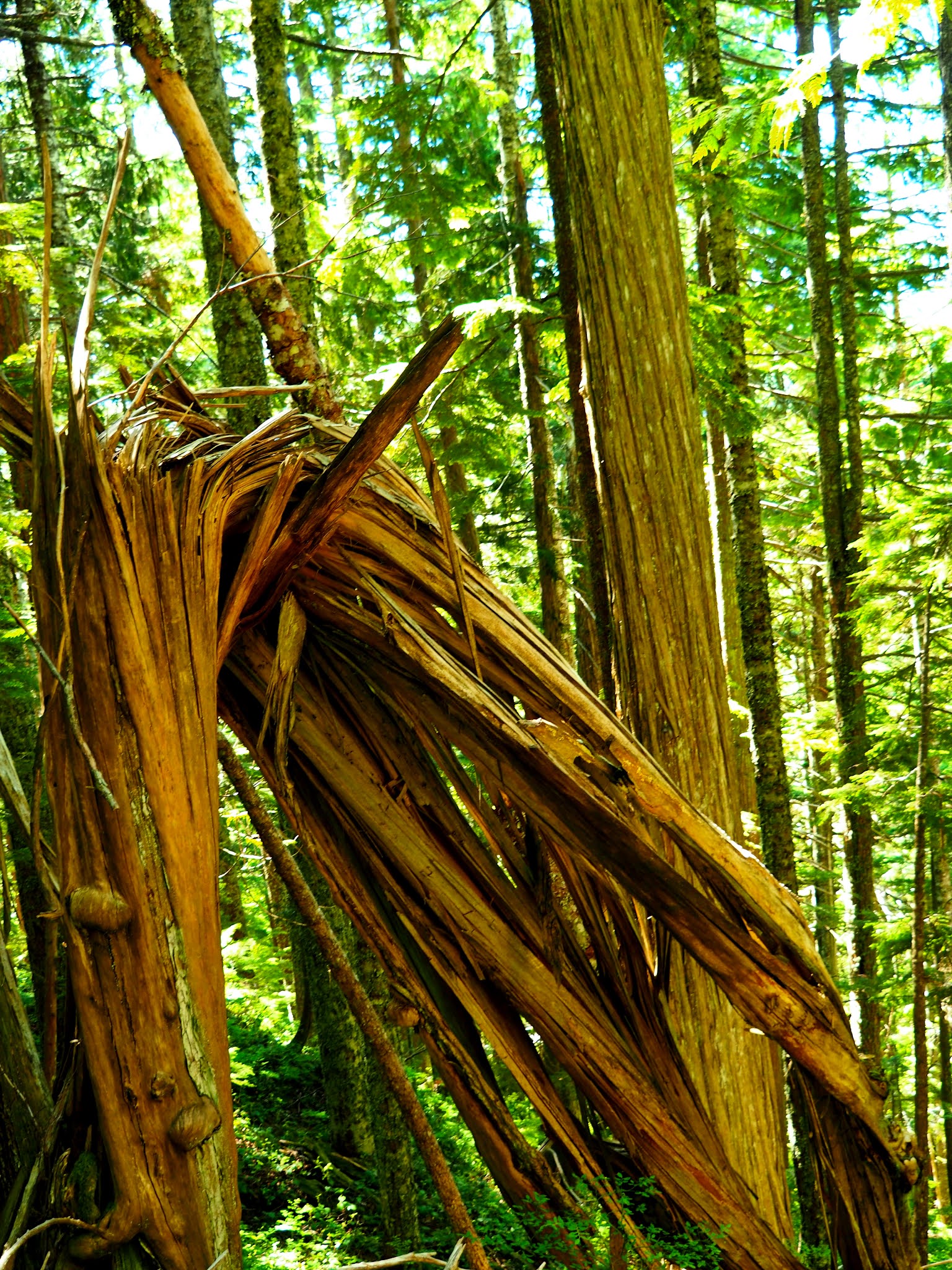
| The fibrous cedar; twisted, folded and mutilated yet clearly retains it's identity. |
 |
| Finally at the bottom three stones mark the end of Branch 21. Up to here the trail has clearly followed an old logging road through the lower reaches, but at these stones the logging road becomes obvious. Behind you lies Walt Creek; a seasonal water flow that may be raging or may be bone dry depending on the season and the rain fall. Don't depend on it. |
The hiker will follow the vestiges of Branch 21 and quickly come to a clearly marked trail dropping sharply downhill to the left. This is the beginning of the Suicide Pass trail that takes the hiker along the headwaters of Suicide Creek between Walt Hill to the north and O'Connell Hill, the last of the Smith Range, to the south. At the bottom of the hill the trail will divide; the SCT will head hard right, turning west, while an old ATV track will continue south to a bridge over the small creek at the bottom of the hill. I have never seen that creek run dry (but it might), so it should be a pretty dependable source of water.
The trail through the Suicide Pass is a true trail winding along the edge of the creek, sometimes right next to it, sometimes at the edge of a large logging cut to the south. The forest is a mixture of old and new growth with a plethora of roots at the ready to trip the weary hiker. There is a good camping spot not too far down the trail with a ready source of water (Suicide Creek) less than 200 meters away. The camping area itself is tucked right into the edge of the forest along the large logging cut bordered by the Deer Creek Road above.
 |
| The old ATV bridge at the bottom of the hill. THIS is important: the day hiker can access the SCT from the Deer Creek Road just above this bridge and cut kilometers off their hike to Walt Hut. It makes a Herculean grind into a pleasant four hour jaunt to the top of the Penstemon bluffs and back. |
 |
| Crossing Suicide Creek near it's headwaters. |
 |
| There is beauty here even in the roots that test how nimble we are on our feet. |
 |
| Looking up at the top of O'Connell Hill from the edge of the campground. |
 |
| The water at the campground. Good signage but a bit of a hike to access the actual water. |
 |
| Below the campground the trail has the telltale flat and straight of an old logging track. |
 |
| typically 3% grade or less. |
 |
| The new version of Conchie Road. Until not too long ago Conchie Road was a faint track developed by conscientious objectors around the beginning of WWII. It's a real logging road right now. |
 |
| Along a rock wall and under a leaning tree, beside a brook, the hiker is indeed on a trail again. |
 |
| Deer Creek, from which the road of the same name derives it's name. |
 |
| Coming down the Smokey Blue Ridge, a winding, well worn trail. |
 |
The trail and the bench all honor "Smokey Smith" a local war hero.
|
 |
| At some points the descent gets a bit steep. Just a few points. |
 |
| And when things get nasty steep, the builders were very courteous. I cannot imagine the toughness of the guys that carted that concrete (and water) up that hill. Either they were really tough or offered free beer to some willing teenagers. |
 |
| Leading up to the stairs; along the edge of a sharp ledge. |
 |
| Through the glen, along the forest edge and down the meandering trail, pleasant all the way. |
And then there is the tea-room. I can't say I have an explanation for those little additions to the trail. Somebody carted in a table, table cloths and some decent china for the two little tableaus I found. It's been a couple of years since I hiked this section of trail (maybe it's time for a re-hike? Tomorrow may be a good idea since, apparently, today dawned Smoke Season) so maybe time has had it's way with the tea-room. The self-righteous purist inside me screams "leave nothing behind" while the light hearted soul hidden deep under the grey hair and the worry lines says "good sense of humor". (the tables are gone now).
 |
| My walking cane gave a little hint of Victorian London Fog. The entire tableau is now gone. More purist but lacking a sense of humor. |
Dixon Road represents the beginning of the next, relatively long trail section along the shores of Lois Lake. The hiker will descend a series of small stone plateaus, cross Stillwater Main and drop down the last few meters of elevation to the Eagle River.
The Eagle River ford is basically a set of stepping stones. It will vary between an easy game of hop-scotch from large dry stone to large dry stone to a challenging ballet performance when the water is running a bit higher. PLEASE keep in mind that there will be times that the dam gates are open-up stream and the Eagle River will be potentially fatal to attempt a crossing. Unless you want to make like Sauron's Ring Wraiths crossing the Fords of Bruinen and washing away to fall over Eagle Falls far downstream, go back up to Stillwater Main and go around this obstacle via the tall bridge crossing downstream.
 |
| I liked the stone and sky apposition. |
 |
| The Eagle River Crossing over two years. Hopscotch or ballet depending on the water level (or, if you are me, just say the heck with it and tromp on through) |
 |
| The old forest on the south side of the Eagle River. Tall green moss covered trees with little brown frogs. And bit of mud sometimes to slow down the tenderfoot. |
 |
A moderately steep but short climb up out of the valley.
|
 |
| The small pond seen from the high trail. I climbed down the wicked steep trail to look at it. I could see the remains of the old river gorge, present before the dam. Then there is the dam: tall and mighty. |
 |
The dam from below and above.
|
 |
| Left over from days gone by...or just a big pizza oven. |
 |
| Just a beauty interlude. An elderly woman in Vancouver once gave me heck for admiring some roses I found while walking home from a conference. She told me to take the roses because I was the first person she had seen that even noticed them. Notice the beauty around you; it's transient. I love roses, but I just cannot grow them; I kill them every time. |
Past the dam, the hiker will track along the shores of Lois Lake; sometimes on a high bank, sometimes right up close and personal. For some of the way the trail is shaded in forest, but it does emerge from the shadows at the Lois Lake Campground and then again at Horseman's Camp farther down. Personally, I chose to stay on the shore at one point between the Campground and Horseman's Camp, just to get a different point of view. I almost regretted that as I had to get a bit creative to cross some of the streams flowing into the lake from the shoulders of Troubridge above.
At no point can the trail be described as challenging or taxing: it's a good rest before the last climb up the towering Troubridge.
 |
| From the Lois Lake Campground in different seasons and different years. |
 |
| A study of the old stump at the dead forest. Note the new sprig of life growing from the rotting top. |
 |
| The flotsam and jetsam found along the layered shore. Each layer is a different lake level, a variable reality for a lake behind and active dam with varying amounts of runoff coming from the surrounding mountains. The skiff on the shore was just me playing artsy with the editing program. And the wreck? Just bad driving I guess. |
 |
Sunrise in August of 2020. Golden hour defined. The only thing better would be to shooting from a kayak or canoe long before anyone else was out on the lake.
|
 |
| The mountains to the north and east on an "uncloudy day" |
 |
| Fireweed and ferns invade a relatively recent clear cut. There is an urge to do a "Sound of Music" run through the weeds right until you trip over the first hidden rotting log. |
 |
| The green tunnel |
 |
| The Green Tunnel in a different season a year later. |
 |
| Down in the glen, the weeds grow thick and the trees grow tall. The trail courses along the lakeshore, crossing a series of progressively deeper coulees, each cut by a seasonal creek. |
 |
The lushness of the forest tells the tale of months of rain and relative warmth: trails overgrow quickly here. The SCT volunteer brigade has an ongoing war to keep the trail clear.
|
The SCT takes a meandering course along Lois Lake, crossing several deep coulees (there is the prairie boy coming out: I have no idea what other name one would use for the shallow hollow cut through sedimentary dirt by a small creek) and eventually turning inland to follow a small creek, through the deep forest, uphill to the Lois Main logging road above.
The hiker will step out of the forest gloom onto the gravel bed of Lois Main and head east (left) down the road about 100 meters. The road crosses over a rushing brook that burbles down out of the dense forest uphill: right there the hiker will find the next section of the SCT: the Golden Stanley to Troubridge Summit via Elephant Lake.
The Golden Stanley Hut, another "open concept" construction, is about 300 meters up the relatively steep trail, waiting for the tired hiker. The hut has a new composting outhouse and access to water from the Stanley Creek a few hundred meters above (south) of the hut. There is a view of Walt Hill through the trees so the hiker can contemplate how far they have come to get there.
 |
| Stanley Creek at low ebb and at full flow after a rain storm. The magic of a neutral density filter and a very long exposure. |
At some point I developed a fixation on Stanley Creek.
At low flow it is reminiscent of a cultured private garden. The gentle creek flows in several separate streams over stones and fallen trees creating a peaceful, contemplative scene that is a feast to the photographer's eye.
At the peak of spring run-off the creek turns into a raging storm, creek beds lateral to the main flow fill and water pours over small water falls that were just stone and weeds a day earlier.
Last year, during spring run-off I drove out the creek to see the raging torrent and test out my new neutral density filters. The hike into the falls is about fifteen paces off of Lois Main, but that day I had to watch my step: ground that was usually high and dry was now under a foot of water or more. I could not hear myself think the roar of the water was so loud. I loved the photos I snapped that day and I thought it could just not get better.
On my way out I noted a small parking area on the north side of Lois Main. I stopped for a moment to read the small sign hanging on a tree at the back of the alcove off the road. Lois Bluffs. Hmmm. That sounded like somewhere I wanted to visit. I put that on my list of places to go, places to see.
The following day I decided to go to look at Lois Bluffs and drove in via Canoe Main. It was raining (of course) and, as I drove up Canoe Main, the stony road was essentially a whitewater cataract. Immediately I realized that the water would not just be a raging torrent at Stanley Creek but a fresh-water maelstrom. I raced out to the creek and was awed by the roaring violence. The photos speak to the flow rate.
On my way out I stopped at Lois Bluffs. In an act of stubborn foolishness, I decided to hike into the bluffs and see what I could see.
To my chagrin, Lois Bluffs are a rock climbing wall. There were even some worn ropes still attached (a faux-pas I'm told; if some fool like me were to trust weathered ropes after a winter of rain and wind, Joe Black might be waiting at the bottom of the cliff to collect his soul). Momentarily discouraged by the blank stone wall, I turned to go back to the car. Then I saw it.
There was a trail edging up the west side of the the monolith, following a narrow ledge of stone. I just had to explore. Up I went, nothing but worn sneakers on my feet, and, of course, the trail just got steeper as I climbed.
So there is a child's tale called "If you give a mouse a cookie". While the story is mildly amusing and very much a child's story, the point is well made: sometimes a series of simple decisions lead to a cumulative disaster. In this case I managed to get about half-way up that trail before I realized I was unprepared, alone, and likely a bit outside my personal envelope. Of course, by that time I was already past the worst of the trail and realized that I might as well complete the climb since I had to navigate the stupidly steep parts anyway.
The pictures were terrible: the clouds had rolled in while I was pretending to be a rock climber and there was nothing worthwhile to see except the precipitous fall to the bottom. I made it back down that darn trail....and lived to make even more foolish decisions.
Ships are safe in port, but that is not what ships are for.
 |
| The Golden Stanley |
 |
| Lois Bluffs in the spring, ropes in place still. |
 |
| Looking more daunting to a guy that cannot climb a ladder without getting a nose bleed. |
 |
| From the ledge trail: what was I thinking or was I thinking at all? |
 |
| This is a real picture of a sky in Saskatchewan. All my neighbors were out in the street wondering at the fish-scale sky....and thinking it meant something apocalyptic. BTW: there was no editing here: the sky really was that color. Beauty is not in the landscape, it's where you find it. |
Bum gall unwaith, hyny oedd llefain pan y'm ganed. I was wise once; that was in crying when I was born. Oh my, how true is that?


Comments
Post a Comment